

Mile 92 – 181
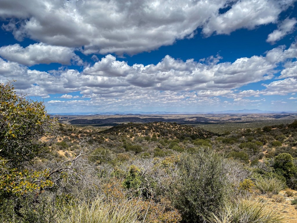
No rain fell from the sky my night out from Lordsburg despite my preparations. I awoke later than I normally would’ve after a restless night sleep and continued my way across the vast plain that stretched north of the small desert town. Mountains loomed before me, but I still had a stretch across the flat expanse before I would reach them. Not long after I began hiking, I saw a figure moving slowly in the distance. I quickly caught up to Tom who I had met the day prior in Lordsburg, and we ended up hiking a little bit together that morning. The trail was not very well-marked, despite the sign posts in place, and we got lost a few times trying to find the correct trail. The scenery became more beautiful the closer we got to the mountains and I left Tom behind as he rested while I pressed onward up the gentle slopes to the first water source of the day. More familiar with the steeper slopes of the Appalachian Trail, I appreciated the gentle climb up the mountain roads, making the 2,000 foot ascent almost leisurely.

The water source was a cow tank kept behind a roughly constructed fence; a few of the cows lingered to watch me fill my bottle and wipe the sweat from my salted face. Tom arrive not long afterwards as I rested in the shelter of the trees
“Welcome to paradise!” I said, arms outstretched.
We ate lunch together and he pressed on ahead of me. The day was hot in classic desert fashion, but sparse clouds rolled across the sky offering brief moments of shade. The trail followed some back country roads that were, at times, a bit precarious for off-road vehicles to traverse. Winding up the mountain, I finally arrived at the ridge line to descend surrounded by trees and immersed in their cool shade.
I took a nap underneath the boughs of a particularly large sentinel only to wake-up a little while later at the approach of another thru hiker, the second I had seen that day, by the name of Doggone. We chatted briefly and he discussed his plans for evading the controlled burn that occupied a section of the trail ahead. Like so many others, he plan to hike the highway 90 into Silver City, successfully evading the burn, as well as, a fair amount of trail. The thought of a 20 mile road walk down a stretch of highway did not appeal much to me, despite the leisurely walking it may offer. I informed him I did plan to go over Burro Mountain (our first true mountain resting just around 8000 feet at its peak) and take the official detour.
I finished packing up my gear and arrived at a small parking lot near the trailhead. A trail angel had set out about 16 gallons of water for the upcoming dry stretch and I eagerly drank a liter before filling up with enough to get me through the next day. I pressed on with the hopes of running into Tom again or at least attempting to make it as far as he did. He mentioned he was a faster hiker in the afternoon and honestly, that’s when I’m at my slowest. My feet, sore after a long day, make me take more frequent stops in the twilight hours, however, I still manage to punch out a sufficient amount of mileage.
I kept my focus upon mile markers, promising myself that I would at least get to the next gate or road crossing and maybe Tom would be there. I ended up stopping just after my second gate crossing at a little patch of dirt in the rolling hills of grass. The next morning I pushed the last few miles to another parking lot to find more gallons of water set aside and a trail angel named Solo entertaining Tom at her white van parked in the relatively empty campground.
After being handed a soda and sitting down on her outdoor rug to stretch, I asked what the water situation looked like between here and the next town.
“From what I’ve read,” she said, talking slowly and deliberately, “there may be water at Red Rock Road. Page from Ravenswing said she would try to put water there. After that, the forest rangers told another hiker that there was some water ahead, but he never found it. I think he ended up getting a ride into town after running out.”
Tom and I exchanged a look as both of us had intended to take the official detour around the controlled burn, but the thought of potentially no water for close to 30 miles didn’t appealed to either of us. After some discourse, we both agreed that a suitable alternative would be to go up and over Burro Mountain to reach the road at Burro Mountain Homestead: an RV park on the northern side of the range. From there, we had a walk down a dirt road and then we were in for a road walk down Highway 90.
“Seven, seven, twelve,” Solo chanted, helping us to remember the mileage between points.
After a quick call home to inform my family of my change of plans and that I would be arriving in Silver City, not on Saturday, but Wednesday evening instead. I called ahead to the Triple Crown Hostel to book a tent space for two nights, as reservations were necessary in the small but popular hostel. After saying my goodbyes to Solo and thanking her for the Coke and Mandarin oranges, I turned to follow Tom up the mountain.
Coming from Michigan, I am not used to hiking mountains that reach peaks at 8000 feet, and the near 1,500 foot ascent certainly took my breath away. Despite it being morning, the heat of the day was already upon me and I took frequent stops at every shade I could find to catch my breath and cool down from the exertion. I encountered my first wild pig near the summit while the last stretch up Burro Mountain caused me to grow a bit dizzy from the climb. I had to stop for a moment in the shelter of the pines.
A final push brought me to the peak, which was devoid of views. I stumbled across Tom lounging in the shade of the sparse trees at the summit. We rested a while together before he set off and I packed up my food to make my way after him.
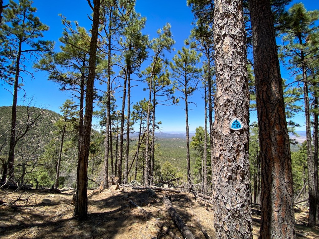
The climb down’s views were spectacular. Since leaving Lordsburg, pine trees had been more common on trail and at these elevations, the mountain side was peppered with them. As I snaked my way along the mountainside, descending via switch back and a winding narrow trail, I took in the views of the range and in my heart, I was content with my decision to summit the peak.
I reach the road junction that led further down the mountain to Burro Mountain Homestead, becoming a bit confused by the aggressive private property sign that adorn the fence. After a brief moment’s hesitation, I found the stile that lead through the barbwire and walked through the long-term RV park campers down to the offices. Checking in with Dave behind the counter, I bought myself a couple sodas and a small cheese personal pizza before settling down on the patio of the activity center with Tom. Excited to use a flushing toilet again, I went to use their bathroom before microwaving my personal pie.
Tom and I discussed our plans for the rest of the afternoon. I hoped to get to the end of Tyrone Road, leaving a 12 mile road walk in the morning, while he hoped to get a bit further. I was a tad skeptical of the camp sites down the highway, but I wished him the best as he packed up and left. Leaving myself not long after, I spotted a familiar pack adorned with flags.

“Hey FGT!” called Roger That from across the small gravel lot that separated the office from the activity center.
“I thought it was you!” I called back, approaching him.
I had met Roger That just once before, under the shade of a juniper tree in a wash, on the hottest section of trail I had crossed so far. He also intended upon taking the official detour around the burn, but, unlike me, seemed relatively undeterred by the lack of water.
“I was a forest fire fighter for about 12 years,” he told me, “and those guys work about 12 hour days. So, I would assume that somebody is there until about seven tonight. I hope to get there by then to talk with them if I don’t end up staying too long here.”
“Well there is cool shade, personal pies, and free Wi-Fi,” I told him, talking up the small park.
“Now you’re talking my language,” he said with a smile.
I wished him luck on his path before setting off again on my own. The first section of the road walk I was in relatively high spirits. I played music and danced my way down the quiet dirt road, although it gradually became tedious and my pace returned to a crawl. I called my sister to get me through that last hour before finding a spot just off the side of the road about a half mile from the highway.
The walk into Silver City the next morning robbed me of any positive feelings I had about going into town. Along the way I ran into 13, Doggone and Topo when I stopped for a sausage, egg and cheese breakfast burrito at Don Juan’s in Tyrone, New Mexico.

The last 5 miles to town made my hips ache and new blisters develop on the side of my toes. By the time I reach Cooper Street with about a mile left to go to the hostel, I was sitting down about every 5 to 10 minutes just to stretch my cramped feet inside of my shoes. At long last, I turned on the Market Road and tapped on the door of the Triple Crown Hostel. Brendon, a former thru hiker himself, brought me inside and gave me a tour of the first and only hostel in New Mexico. After being handed a towel and washcloth, I went to set up my tent between Tom and Sunshine’s in the tight dirt swatch.
Brendon remarked, once that I had set up my Tarptent Notch in between Sunshine’s MSR and Tom’s own Tarptent, that there must be at least a few thousand dollars worth of tents up on the small hill. I went to take my first shower in nearly a week and sat on the floor of the tub as I aggressively scrubbed at the filth from my limbs.

When I was clean and wearing the complementary town clothes that most hostels offer as you wash your hiking clothes, I went with 13 to the local brewery, Little Toad Creek, and enjoyed a burger and some beer with her and Topo. Returning to the hostel, I spent the afternoon doing some chores, but mostly tried to relax my aching feet in the shade of the open side porch.
That evening Brendon and a few other locals came together around the fire and played folk songs in a little jam session for the benefit of the hikers. It was such a relaxing evening sitting around the little fire and enjoying the cool evening desert air. The next morning, I began to do my actual chores. I rode one of the loaners bikes into town and collected the brunt of my resupply, not just for the days ahead but also enough to ship a box up to Pie Town, a town known for its pie shops and little else. I had to wait for Brendon to return from rescuing a dehydrated hiker from the Gila River, before Beer Goddess and I got a ride up to the UPS store to mail our food ahead of us.
My second day in town was not nearly as relaxing as the first. Although my feet received the benefit of some time off, I was exhausted and there was still work to be done even when you are taking a rest day. Between phone calls home, managing my resupply, cleaning and patching my gear, by that evening I was exhausted and ready to crawl early into bed. Despite that, we shared in a family meal of chicken drumsticks, potatoes, and salad with the hikers at the hostel.
There was one more thing I had to do the following morning before I could leave town and that was walk down to the local outfitters to check for a new filter for my Katahdin Be Free water filtration system. My mom had purchased me one for Christmas, and I foolishly had not checked it before I left. I hate filtering water, so for this trip I chose a gravity filter that allowed me to fill up the 3 L bag and stick a hose into my water bottle, saving me the time and annoyance of filtering water in camp. As grateful as I am for the gift, she had unknowingly purchased me the regular filter head instead of buying me the gravity filter attachment, making it impossible for me to use the bladder as I had intended.
After getting breakfast at Tranquilbuzz and waiting for the outfitters to open, I checked both shops in town, but neither sold the attachment I was looking for, so I resigned myself to the filter I had. I got myself a second iced mocha coffee on my way out of town and was so distracted by the wave of new hikers coming in that I ended up leaving later than I had intended.

I had about a 6 mile road walk down Little Walnut Creek Road to get to the Gila National Forest, and again I was turned off by the endless stretch of pavement. Upon reaching the picnic area, I rested my feet for an hour before setting off a little further up trail. Coming to a forest road junction, I was greeted by a small black dog and her owner, Cheshire Cat. Cheshire eagerly invited me back to his car which he had parked just a little ways up the narrow forest road for a bit of fruit and a moment’s rest. I thanked him for the orange he handed me and played fetch with his puppy, Stella Blue, who was about as loud and vocal as a human child. Departing to allow him to go for his evening walk, I trudged the last few miles to Bear Creek campsites.

Moonshine, a hiker from the hostel, came and passed me as I walked up the forest roads and I arrived in the camp just before dusk that evening, feet aching from the road walk and tired after a long day. I set to work immediately, quietly pitching my tent as Moonshine, Lonewolf, and Mona Lisa chatted around the empty fire ring.
I join them for dinner before returning to my tent and falling asleep quickly in the cool shade of the river valley. I was the last to leave the following morning, partially due to my continual inability to wake up early, but also to allow the other some time to get ahead. I had become accustom to hiking alone and I didn’t much relish the thought of struggling along with others in tow. The day started off pleasant enough until a Toyota stopped me along the road. They asked if I was a CDT hiker and, when I admitted I was, they grew a little confused about the path that I was on. Confident I was going the right way, I shrugged off their concerns before saying my goodbyes. After their car pulled away, I checked Guthook, my GPS tracking app on my phone, and realized that my confidence was unjustified. Mistakenly, I had hiked a mile and a half down the road and missed the turn to Sycamore Creek Canyon trail. Not the way I had anticipated starting the day, I turned back around to walk the mile and a half back, losing an hour of time and gaining three unnecessary miles to the day. Finding the trail head easily enough, I caught up with the three older hikers who had stopped me on the road. Admitting I was wrong and thanking them for stopping me or else I would’ve hiked all the way to the highway, I pushed on through the ill-maintained canyon. The trail does not allow for easy hiking with its loose stones, frequently creek bed crossings, and the downed trees that littered the path.
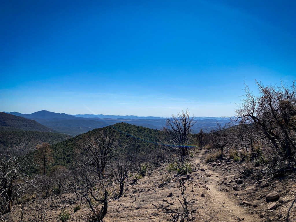
I broke free of the tree line to make the climb up to Tadpole Ridge in the heat of the day. I stopped briefly for lunch at a small pool of water, and then descended to climb back up to the ridge. The fires from May 2020 had destroyed the trail, and I spent a majority of the afternoon bushwhacking, getting lost, and tearing up my legs as I struggled to find the correct path up the mountain. Tired, hot, and frustrated, I finally found the official trail again and took an hour rest for a morale break in a small clearing free of fallen trees or threatening burnt branches.
With the plan to reach the Gila River that evening, I reluctantly got up and dragged myself further along. I had started climbing the last push to the summit when I ran into Cyclops coming back down. He was out of water and had gotten lost at the peak, unable to find the trail. I gave him my spare half liter as Sugar Mama, the second hiker I had seen that day, arrived to chat.
Defeated, Cyclops headed down the mountain and Sugar Mama and I joined forces to find our way to the summit. Both of us were exhausted and grateful for the company after a hard day of hiking. We had only gone a few more miles before running into Cheshire Cat again. We joined him for the evening, hopes of arriving at the Gila River long since abandoned and he made us dinner out of the back of his illustrated car.
My third day out of Silver City, I knew I needed to push it. I woke-up feeling amazing and crushed the first 6 miles with ease down to the Gila River, but once I arrived, my pace was forcibly slackened. The Gila Alternative is a popular side trail many CDT thru hikers take opposed to the official route. The trail has over 150 river crossings, none of which allow you to keep your feet dry, and the southern section was not well maintained. My pace lagged as I tried again and again to find the trail, the correct section of river to cross, and to prevent myself from getting torn up in the underbrush.
My normal pace at 3 mph, I was doing maybe 1-2 during the beginning, and I was becoming increasingly frustrated. Every time I checked Guthooks, it felt as if I had hardly moved despite feeling exhausted from the latest stretch. It took all day for me to hike through the river, but as I got further north, the trail became better marked and more traveled, and my pace was able to increase.
I ran into Crocks and Jibs, who I had met at Triple Crown Hostel, and they told me Sugar Mama had a gone a mile further to a small campsite next to some natural hot springs, which was also my intended endpoint of the day. I forced myself down that last mile, angrily pushing myself faster to end the day after 11 hours of steady hiking.
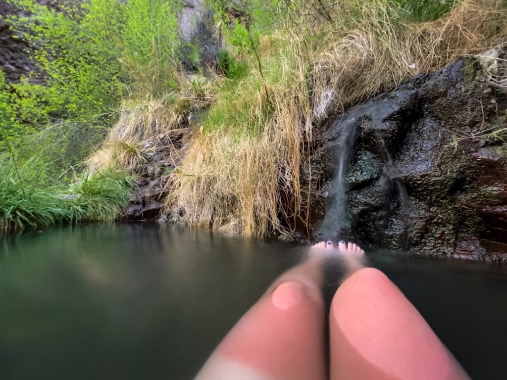
I was wiped when I arrived, but the little pools of hot water was well worth it, and I floated serenely in the silty waters.
I learned 19 miles through the Gila River in a day was attempting to accomplish too much, and I still had nearly 60 miles of river ahead of me. I vowed that evening, as I set up my tent, that I would take an easier day into Doc Campbell’s Outpost in the morning for my resupply, and aim for shorter mileage while traversing the river. It had been a hard few days of trail, between bushwhacking, getting lost, and the 50 river crossing I had done thus far.
I snuggled up warm and very sunburnt, but content in my tent and passed out quickly in the shimmering moonlight.


I love reading about your adventure. Proud of you.
LikeLiked by 1 person